 Skip to content

GPS Land Leveling System for Precision Agriculture
Maximize your agricultural efficiency with our GPS Land Leveling System. Achieve precise land leveling for optimized irrigation and crop growth, ensuring improved soil management with the best GPS for land leveling.
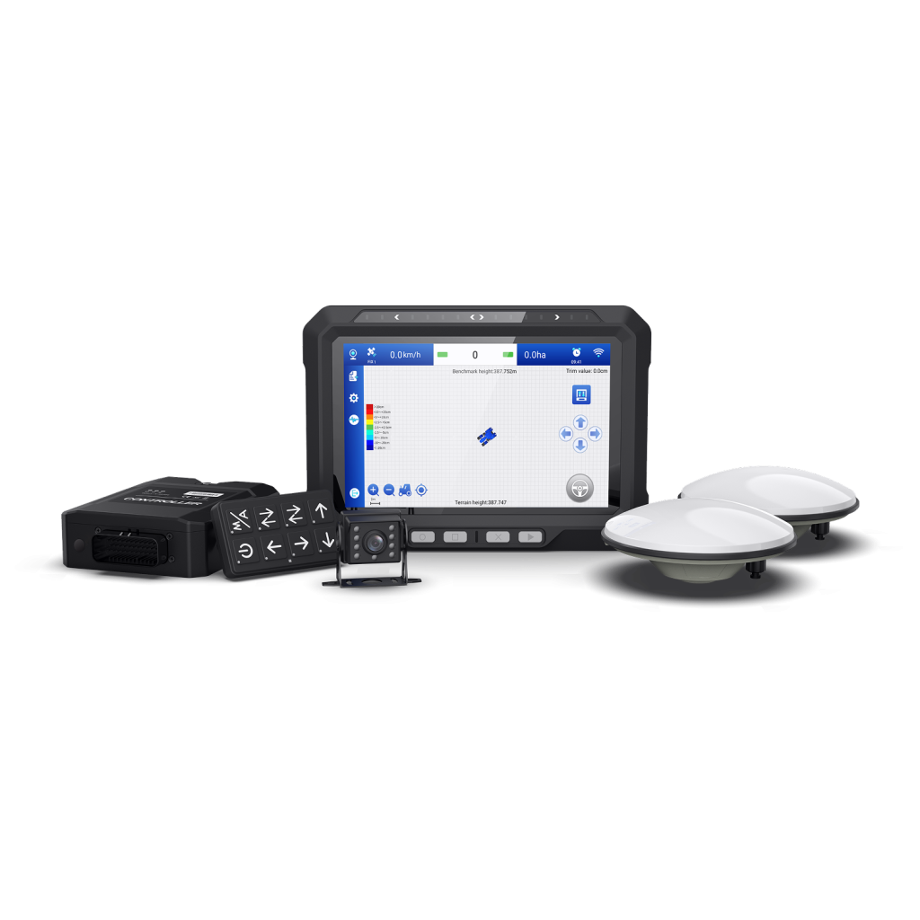
W20 Land Leveling System
Why Choose AllyNav For Land Leveling System
The AllyNav W20 GPS Land Leveling System offers farmers a precise and efficient solution for land leveling with GNSS accuracy up to ±2.5 cm. This system is designed to seamlessly integrate with various GPS land leveling equipment for both large-scale and small-field operations, optimizing water distribution and improving crop productivity.
With advanced RTK GPS land leveling technology, the W20 provides unmatched precision in leveling tasks, regardless of terrain complexity. The system operates efficiently using advanced RTK, VRS, and PPP-RTK correction services, ensuring consistent and accurate results without the need for fixed base stations.
The W20 integrates effortlessly with tractor leveling equipment, enhancing your existing farming setup. It supports a wide range of machinery and is adaptable to different agricultural requirements, from plowing to harvesting. Additionally, its ISOBUS compatibility ensures that it works seamlessly with various implements, increasing operational flexibility and reducing downtime.
Designed for durability, the W20 offers stable and reliable performance even in harsh field conditions. Its user-friendly interface provides real-time data monitoring, allowing for effective task management and long-term optimization of farming processes. Whether you are using GPS land leveling for irrigation or soil preparation, the W20 ensures that your fields are leveled with precision, contributing to overall farm productivity and sustainability.
Explore Advanced Precision Solutions
Empower your farming operations with cutting-edge technologies designed to enhance every stage of your fieldwork—from precise land leveling to efficient spraying.

Auto Steer Systems for Tractors

Precision Spraying

Precision Seeding

ISOBUS
Looking For Complete Field Automation Solutions?
Frequently Asked Questions
How does GPS technology improve land leveling accuracy?
GPS land leveling uses satellite signals to calculate the precise position and height of the equipment. This technology enables measurements to be accurate within centimeters, even over large areas, ensuring uniform land grading and optimizing water distribution.
Can GPS land leveling systems be used on all types of terrain?
Yes, GPS land leveling systems are suitable for both flat and rolling terrains. They can operate effectively on various land types by adjusting blade or bucket heights through hydraulic systems, regardless of terrain challenges.
What are the operational modes of GPS land leveling systems?
GPS land leveling systems can operate in both manual and automatic modes. In manual mode, operators control the blade based on display inputs, while in automatic mode, the system takes charge of hydraulic controls for more efficient and consistent leveling.
How does AllyNav’s GPS Land Leveling System stand out from other systems on the market?
AllyNav’s GPS Land Leveling System offers high-precision grading with an accuracy of ±2.5 cm, integrated Auto Steering, and advanced correction services like PPP, VRS, and PPP-RTK. The system’s ISOBUS compatibility ensures seamless integration with a wide range of farming equipment, offering farmers efficient and cost-effective land leveling with minimal operational effort.


")


